Saturday, July 3, 2010

June 30th Israel Travel and Impression Report


We left the En Gev resort area on the Eastern shore of the Sea of Galilee this morning. It was already beginning to get hot. Yesterday it was 106 degree at the resort area. I was really looking forward to getting back to Jerusalem up in the Hills of Judah. We had several places that we were to make stops as we traveled south toward the city.
Our first stop the Cliffs of Arbel. These cliffs are easily visible from the Sea of Galilee as they look over the Western side of the lake just north of Tiberius. From these mammoth cliffs one can easily see the path of the Patriarchs highway as it moves northeast of Mt. Tabor past the Horns of Hittim and through the cliffs of Arbel onto the Plain of Gennesaret. As the highway continued it would move north past the Sea of Galilee and onto Hazor. On the far end of the Gennesaret plains is the biblical town of Magdala the hometown of Mary Magdalene. The southern end of the Arbel cliffs rise up from the valley below with fields of wheat and barley being cultivated up to the National Park line. The view from this point is stunning and encompasses much of the area Jesus did ministry while in Galilee.
Our next stop took us to the city ruins of Zippori (Sepphoris). The city was the first capital of Herod Antipas who was granted the Galilee to rule after his father’s death in 6AD. He eventually moved his capital to the city of Tiberius on the Western side of the lake. Zippori was the main headquarters for the Crusaders as they embarked upon their fatal journey to defeat at the hands of the Muslims. Before the Great Rebellion of 66-73AD, the Jewish residents of Zippori made a pact with the Romans which did spare their lives and their city as the rest of Israel including Jerusalem was destroyed. The Jews lived in the upper end of the city. The ruins at the lower end of the city provide us with beautiful mosaics. The city had a north south street (Cardo) as well as east west street called the Decomono. The streets where stone with walk ways under columned porticos on either side for pedestrians. Besides the huge mosaics that have been unearthed at this site, the most interesting to me personally were the indentions found in the road made by the wheels of chariots over heavy use.
After lunch in the Harod Valley near the spring where Gideon’s men drank, we moved onto the ruins of Beth-shan. Beth-shan was the Roman city of Scythopolis, the capital of the Decapolis and the only one on the east side of the Rift Valley. The ruins were from the Byzantine period again showing the main Cardo (north south) road and the Decomono. The Cardo was lined again by walk ways under porticoes. This city also possessed a sewer system with the road being crowned to move rain water to the sides. The main road proceeds north until it hits Tel Beth-shan the older part of the city under a huge Tel. On the Tel there are remains of 26 different cities that had been built and destroyed, including the city on the east side of the Tel that is from The United Monarchy time. This is the city where the Philistines took King Saul’s and Jonathan’s bodies and hung them for all to see. The city does sit in the Beth-shan Valley where many Israelites would see the bodies. Saul and Jonathan were killed on Mt. Gilboa and their bodies taken to Beth-shan and hung as a warning to all Israel. One of the final things we were able to see at this site was the latrines (men) that lined two walls of a great room. They were humorous at the least.
My impression for the day center once again around the reality that biblical events took place on these sites many years ago. They once again have added clarity and color to the account of both the Old and New Testament.

Picture One - View of the Genessaret Plain (Magada and north end of the Sea of Galilee from the Cliffs of Arbel
Picture Two - ibid
Picture Three - Chariot ruts in the road at Sepphoria
Picture Four - Theater at Beth Shan
Picture Five - View from the Theater with the OLD Tel Beth Shan in the background. This was the city where Saul and Jonathan's bodies were hung

June 29th Israel Travels and Impression


Of all the days I have spent here in Israel, today by far was my favorite. We visited many of the sites where Jesus did ministry around the Sea of Galilee. These places came alive from the vividness of Scripture connected to actually being at the site. My personal study into the life of Jesus particularly from Mark’s Gospel, was so real today. I am grateful for the year of study that I gave to walking through this Gospel.
Our first stop was at Kursi /Gergesa where a church had been erected memorializing the event of Mark 5:1-20, Jesus delivers the Demonic of a legion (6000) of demons. This is located on the east side of the Sea of Galilee just a few miles from the resort we have been staying at for the last three days. Just south of this church was erected there is the only steep embankment where the herd of pigs could have run down into the Sea of Galilee. Just a little ways further south, near ancient Hippo archeologists discovered ancient tombs. These tombs easily could have been the place where the demonic was living. This whole region is also called the Decapolis.
The ruin at biblical Chorazin was our next stop along our north east route around the Sea of Galilee. The ruins of this ancient city are referenced by Jesus in his curse upon what some call the Evangelical Triad and includes Chorazin, Capernaum, Bethsaida (Matt. 11:20-24; Luke 10:13-15). We were able to view a synagogue from the first century BC. Discovered in this synagogue was the place where the teacher would sit and preach his message to his audience. This place is called ‘the seat of Moses’. This would have been the type of seat that Jesus used whenever he taught in the synagogue. This is what he would have been teaching from in Mark 21-28, when he taught in the Capernaum synagogue and was interrupted by the demon possessed man. We were also able to see a covered miqvah from the same time period.
Our next spot to visit was a Church that was built to memorialize the place and event of the feeding of the five thousand. There isn’t any real consensus as to the exact location for this miracle of Jesus but it does give pilgrims and tourists a spot to at least commemorate this event. The spot selected was on the northwest side of the Sea of Galilee. After visiting the church, we took a walk down the hillside and stopped at a spot near a plowed field. In that location we had all types of soils that Jesus would have referred to when he taught the Parable of the Soils in Mark 4:1-25. A little farther down the hillside we stopped and talked about Jesus giving His disciples the Great Commission. Even though these are probably not the exact spots of these events it was good to be on the hillside of Galilee thinking through these biblical events and lessons from Jesus.
Capernaum was my favorite stop of the entire three weeks. My imagination took me back to the New Testament with numerous passages and stops in the old city. The demon possessed man in the synagogue of Mark 1:21-28 came to life when I was able to see the 1st century foundation of the synagogue. To think that this was the possible site of this event was moving. I was also moved by the ruins of the houses as I thought about the paralytic being lowered through the roof of the house in Mark 2:1-12 was incredibly visual. And to see the potential spot of Peter’s house and to image the events and discussions that took place with Jesus and His disciples. This stop was worth the trip for me.
Our final stop was really a moving stop with a boat ride across the Sea of Galilee from Tiberius to Ein Gev. The boat ride gave us a great view of both sides of the Sea as well as time to meditate on all that we saw and experience during the day.
My final thoughts of the day reflect back to Capernaum and the things that I felt and experienced while looking at the ruins. I have acquired much knowledge over the past two plus weeks. But I think I was challenged today to be more sensitive to God’s leading as Jesus was in everything that He did. I was also struck with a longing not just to know about Jesus but to really know Him more intimately. Jesus did not give His life by dying on the Cross so that I might possess eternal life. He died so that I might die to myself and live for Him. I long to have a more intimate daily filling of His Spirit so that I may please Him and enjoy Him. May I be covered in the dust of my Rabbi Jesus.

Picture One - The possible location of The Healing of the Demon at Gergesa where the pigs ran down the hill
Picture Two - Miqvah at Chorizim
Picture Three - Seat of Moses at Synagogue in Capernaum
Picture Four - Possibly Peter's House in Capernaum
Picture five - lower rocks show the 1st Century foundation of the Synagogue in Capernaum

June 28th Israel Travels and Impression Report


Our second day of the Galilean filed trip began with a stop at Tel Hazor the city along the most northern part of the Patriarchs highway. Hazor sits in on the west side of the Hulah Valley. From Hazor one could continue up the Rift Valley or go east to Damascus. Hazor was a key intersection in travel in the Old and New Testaments as well as the route invaders took to possess this vital real estate. Archeology has uncovered a gate named the ‘Solomonic Gate’ which by its name tells us that it is believed to date back to Solomon’s reign during the United Monarchy.
From Hazor we traveled north to Tel Dan up dear the beginning of Mt. Hermon. The springs at Tel Dan are one of three headwaters of the Upper Jordan River. Dan is the city (Leshem) that the tribe of Dan conquered in the hill country during the conquest (Joshua 19:47). They were tired of or unable to overthrow the Philistines so they moved to the hill country of upper Galilee and attacked this city and renamed it Dan. There are multiple gate systems that were discovered in this city. Dan is, along with Bethel one of the two cities that Jeroboam placed the golden calf when Solomon’s kingdom was divided. It seems that in the high place of the city an elaborate temple system was discovered with a huge altar and an additional building behind that has been speculated to be the place of the golden Calf.
It is easy to understand why this city was a desired place. The springs of Dan even in July shows a powerful flow of water that would be plenty to support a thriving city. The waters flow from the filtering of winter snow melt and rain that flows to the clay line of Mt. Hermon and out the Dan Springs.
Caesarea Philippi was our next destination. Another one of the headwaters flows out of the mountain at this spot. This is the location of Peter’s great confession in Mark 8:27-30. There is evidence that several Temples to false gods were established here during Jesus’ time. When Jesus asks the disciple ‘Who do people say I am?’ as well as ‘Who do you say I am? He had the temples in mind. It was this backdrop that provides us with the clear clarion confession of Peter.
Today at the foot of the Temple ruins flows from beneath the Banias Springs (second headwater of the Upper Jordan). In the time of Jesus the spring flowed from the cave where one temple had been built but due to earthquake activity the outlet for the spring is now at the foot of the hill. Our hike for the day was downhill to a location that lead us the Banias Falls. It was absolutely gorgeous, cool, and refreshing. It is hard to believe that in this hot, dry region of Israel we would find an incredible spring with such beauty and refreshment.
Our last part of today’s filed trip took us up into the Golan Heights where we were able to look over the ‘no man’s land’ into a United Nations Base and over into Syria. I was impressed once again by the vastness and yet the small nature of this part of the world. In a matter of hours you could be in Israel, Jordan, West Bank, or Syria. Yet, the whole time I have felt completely safe.

Picture One - Sea of Galilee from Ein Gev at night 25 yards from our cabin
Picture Two - Tiberius at night from across the Dead Sea
Picture Three - Springs at Dan
Picture Four - The Kings seat at the Gate of Dan
Picture Five - Possible high place of Golden Calf of Jeroboam

June 27th Israel Travels and Impressions


We left Jerusalem this morning early for a 4 day field trip into the northern regions of Israel. Over the next several days we will be covering Samaria, Jezreel Valley, Golan Heights, Upper and Lower Galilee. The later areas are what brings real excitement to my heart I will have the opportunity to place the biblical texts with the biblical place.
Our first stop along the way brought us to the Sharon Plane north of the Philistia Plain and south of the Carmel range. Along the shore of the Mediterranean Sea is a city called Caesarea Maritime. This was a city in which have a rich history and a historical connection to the NT. The city was built by Herod the Great in 22 BC. This is also the city that Peter visited and where he led the first Gentile to Christ (Acts 10). The city has had several major periods of growth including the Crusaders and during the Byzantine period. This city is also known in the Bible for being the place where Paul was speedily taken after his arrest. He was taken to Herod’s palace and help in prison for 2 years here in Caesarea. This would be the place where he received his hearing with Herod Antipas (Acts 23)
Leaving Caesarea we made our way through the Jokeneam Pass through the Carmel Range into the Jezreel Valley. The Jezreel Valley is a very fertile valley and is a major east west route as well as a North South route . We stopped on top of We took some time on Mount Carmel to read about 1Kings 18 and the great confrontation of Elijah and the prophets of Baal. To be at the possible site of this event was rather eye opening. We could see the spring at the foot of the Mountain where the servants brought Elijah water. We could also see off to our right the Kishon Valley that lead into the Acco Plain were the pagan religions of Baal had seeped itno Israel. It was in this valley where Elijah chose to slaughter all the prophets and priest of Baal after God sovereignly revealed Himself and consumed the sacrifice answering Elijah’s prayer.
Our next stop took us about 10 minutes down the road to a place called Megiddo. Today there is a Tel standing where the city once thrives. This city rests at the northern end of the Megiddo Pass through the Carmel Range. This valley pass and the city of Megiddo had been destroyed over 25 times. Ahab fortified the city in his day and had a palace located there. The Jezreel Valley is at the north end of the ancient city. Biblical prophecy tells us that one day the final battle of all time will take place at this location, the Battle of Armegeddon.
Leaving Megiddo, we made our way through Nazareth and on the Ein Gev on the eastern shore of the Sea of Galilee. This is our home for the next three nights. Around the northern end of this fresh water lake is where Jesus performed many miracles, called His disciples and taught many. In a few days we will spend time driving around the Sea of Galilee talking about these various accounts in the life of Jesus.

I am reminded as I sit here looking out across the Sea toward Tiberius. This is where Jesus called His first disciple to leave their nets and follow Him. These men were not the best of the best. But He believed that they could be like Him. Lord, let me follow as they did. “It is amazing the freedom we find from the things we leave behind.

Picture One - Caeserea Maritime Theater
Picture Two - Caeserea Maritime hippodrome
Picture Three - Me on Mount Carmel
Picture Four - Solomonic Gate at Megiddo
Picture Five - My first view of the Sea of Galilee

Friday, June 25, 2010

June 24th Travels and thoughts


Our final day of this three day field trip was spent in the Negev of Judah. I think most of us were ready for the cooler temperatures of Jerusalem. Today we would visit the Fortress of Masada, Ed Gedi, the Dead Sea and Qumran. These are places that I was personally looking forward to seeing and experiencing.
Our first stop was the Fortress of Masada built by Herod the Great as a fortress/retreat. The fortress became famous not because or Herod but because of the Zealots who inhabited this dwelling from 66-73 AD. This fortress sits over 1300 feet above the surface of the Dead Sea with the Northern palace tier sitting at what would be Sea level. We approached the fortress from the West bringing us to the base of the western wall where the Roman Siege ramp is still evident today. We made our way into Masada by a path and steps that ran along the right side of the siege ramp.
The Zealots remodeled Masada when they began living here in AD 66 knowing they would be out of the reach from the Romans who would eventually destroy Jerusalem in AD 70 in the Great Rebellion. Archeologists have found a synagogue as well as several miqvah (ceremonial washing pools) built according to Jewish requirements on this site. One of the western rooms contained a scroll of Deuteronomy and as well as other sectarian scrolls. Massive storerooms were discovered where food supplies were kept. These storerooms were burned before the mass suicides took place.
Our journey from this mountain fortress was by way of the snake path on the eastern side facing the Dead Sea. The path took us 1300 feet back to floor of the Rift Valley. This journey down was filled with steps, twists and turns. Being afraid of heights brought more challenges for me as you can imagine.
Our next stop was across the street from En Gedi where we took our lunch break. While several were preparing lunch the others of us took a dip in the Dead Sea. I was amazed at how blue (no comments) the water looked. I had assumed that since the Dead Sea was dead that it couldn’t be as clear and blue as it was. The Dead Sea is 25-30% slat. The mineral makeup of the Dead Sea is extremely good for your skin. After about 5 minutes I knew that I could check ‘swimming in the Dead Sea’ off of my bucket list. I washed off and helped with lunch preparations.
Our time spent at Masada and the Dead Sea took longer than expected so we were unable to stop at the caves in En Gedi. En Gedi would be one of the places that David and his men hid while fleeing from King Saul. There is the spring located here that would have allowed David and his men to be able to sustain themselves. This would be the probable location where David wrote many of his Psalms. Next time back in Israel this will be a place I would like to visit rather than just drive by.
Our last stop was the Essene remains of Qumran. The Essenes were a religious community that had separated itself from the main stream of Judaism in order to seek the coming Messiah and a more righteous and personal observance of faith. The remains found here contain a kitchen, scroll rooms, numerous ritual cleansing pools, miqvah but yet no indication that people lived on the site giving archeologists the thought that the inhabitants of the community lived in tents or the surrounding caves.
The caves in the area produced what we know today as the Dead Sea Scrolls. Several of the caves are no longer in existence such as caves 7-10 due to the soil the caves were carved out of. Cave 4 is the cave that we see in most pictures of this area. We were able to travel about a mile down the road off the beaten path to explore cave 11. This cave produced a copy of all the Psalms and a few other significant finds. The cave looked like a cave but understanding the significance of finding these scrolls back in the late 1940’s made the stop an incredible experience. To be at the place where OT scholarship received validation of the OT Scripture dating back more than 1100 years from previous copies of the OT gives credence to God’s ability and demonstration of His sovereign preservation of the Scriptures.

Picture 1 - Our lead guides to Masada
Picture 2 - Masada west side up the siege ramp
Picture 3 - steps up the west side
Picture 4 - Dead Sea from Masada
Picture 5 - Cave 4 Qumran

June 23 Travel and thoughts


We spent last evening and again this evening in a Youth Hostel in the city of Ashdod, another ancient Philistine city of the ancient world. Ashdod is a small but yet develop city of Israel. In most of the places that we have been in and through are quite modern as well as diverse in ethnicity. Ashkelon and Ashdod have large Russian Jewish populations. I have found the found in Israel to be very palatable. The fruit of the land of Israel is extremely favorable compared to the same US food.
Our journey today took us to both Eastern and Western Negev with Beersheba being at the cross roads between the two regions. Again this area of southern Israel is very dry and arid. We were blessed today with a strong westerly wind. It is in this area that we find both the Wilderness of Zin and the Wilderness Paran. Time did not permit for us to go to the Wilderness of Paran but we did spend a good amount of time in the Wilderness of Zin. One of the best stops of the day was at the Wadi Zin, a deep canyon that in the rainy season becomes a vibrant river and depending on the amount of rain can be a raging river. Now, it is important to remember that this area of Israel receives less than 4 inches a year. My thoughts on this deep canyon were not formed solely by the small amount of rain but initially started by the receding waters of the flood.
Beersheba was an interesting stop. Ancient Beersheba was the location in which Abraham settled (Genesis 21) and we find Jacob leaves this area after he deceived Esau leaves Beersheba for Haran.. This is one of the cross roads from the south to the north in ancient Israel. The most amazing item from the ancient ruins was the water systems that were used to collect the few inches of water that does allow life to exist from deep wells lined with rocks to wells dug in the valleys for the flocks to use. One well found in Beersheba is over 130 feet deep down to the water table.
Our last stop was the ancient ruins of the Nebataean settlement Avdat. This was built by the same group of people that are responsible for Petra. This people group converted to Christ and tore down their temples and built Christian Churches. Outside of the city walls is a second or third century Romans ruins of what used to be an established entity.

Overall, the day was much better than yesterday June 22. In my mind there were numerous biblical connections that I will carry into my study and teaching of Scriptures.

Picture 1 - city ruins
Picture 2 - Beersheba of OT times
Picture 3 - Me at one of the ruins
Picture 4 - Ibex in theWwiderness of Zin right at Wadi Zin

June 22 Travels and thoughts


We started early in the morning with the packing of our belongings for a three day road trip into the Shephelah and Negev region of southern Israel. This region is within the tribal allotments of the tribe of Judah and Simeon.
The land is hot, dry and incredibly vast. It is hard to believe that people live in this region of Israel. This area of Israel would be the same area that Abraham and Isaac would have been in at various times in the OT.
One of the first things that we were able to see as we journeyed through the Hussan Valley route from the hill country of Judah down to the Shephelah was an old Roman road. This very easily could have been the road that the Ethiopian Eunuch was traveling when he was reading the Scriptures and prayed that god would send someone to teach him (Acts 8:26-40). Philip was brought to the Eunuch teaching him and baptizing him. The Romans later cut steps into the cenomanian stones in places in order to make the travel easier for travels.
Our first major stop was at the Bel Caves at Meresha. The bell caves were started by cutting a round hole through than terra rosa soil (sp?) and begin digging through the harder rock for building. These caves were massive from top to bottom and were shaped in the form of a bell. This was done not by design but by the progress of the work. The workers once through the hard solid on top would begin moving their work in an outward direction as they moved deeper into the ground. It is amazing how much cooler the caves were than on the surface of the ground. Dr. Mullins explained that Jewish priests during times of Romans persecution who had lost limbs in the arenas to lions were sent her to live out their lives.
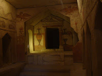
At the same sight just a few hundred yards away, a ancient Sedonian Tomb was found. The tomb probably belonged to a wealthy family. When discovered and completely unearthed the tomb was remarkable. The walls were covered with very colorful drawings of animals and people. The tombs were probably 3rd century AD and were plenty big enough for 20 plus people.
We made a quick stop at Tel Lachish one of the former Philistines cities. The city was a pivotal city in the ancient world along the inner coastal highway and in many ways was a last defense guarding the Lachish Valley Route that would connect with the Patriarchal Highway along the ridge of the Judean Hill country that would lead to Jerusalem. Still visible at this site is the siege ramp that Sennacrib built somewhere around 701 BC as he was making his way north to Jerusalem.
Our last stop of the day brought us to Tel Ashkelon, another Philistine city along the Mediterranean Sea. Several years ago the Canaanite gate was discovered revealing architecture previously credited to the Romans but found here dating before the Romans. This ancient city was spread over acres along the sea coast.
The Mediterranean Sea was beautiful. The wind was blowing in from the west bringing huge waves crashing onto the beach. Although it was good to relax at the beach, the day was my least favorite day of the trip so far. Not quite sure because there were many significant visits along the way.
Picture 1 - Old Roman Road
Picture 2 - Looking from Tel Azekah on the Elah Valley - place where David slew Goliath
Picture 3 - Meresah Bell Cave
Picture 4 - Sedonian Tomb
Picture 5 - Mediterranean Sea

Sunday, June 20, 2010

June 19th Travels and thoughts


Today was another full day field trip. Our first stop was the Wadi Kilt a deep valley that runs east toward Jericho and the Jordan Rift Valley. This was an incredible stop somewhere near where the Roman Road would have passed from Jericho to Jerusalem. This is just one of the three main routes in the Bible times that would have been traveled as people came up to Jerusalem. This Wadi is located in the Judean Wilderness, so it was dry and hot. Overlooking the deep and steep valley walls brought several biblical accounts to mind. This would have been the area in which the Holy Spirit led Jesus into for the 40 days of fasting and temptation in Mark 1 and Matthew 4. This would have been the setting of Jesus’ parable of the Good Samaritan (Luke 10). This puts quite a perspective on the places and events of the Bible. Looking out over the hot, arid wilderness made it very clear that the conditions of the wilderness would have made Jesus’ temptation that much more difficult.

Coming out of the Judean Wilderness brought us to the location of the NT Jericho which is on the southern outskirts of modern Jericho. We took some time to look the ruins of another of Herod the Great’s palaces. We then drove through modern Jericho and stopped at a Sycamore tree. The story of Zaccheaus was read just to put the tree and the story into context. We then proceed to the site of the OT or Joshua’s Jericho located to the north of modern Jericho. The city has been rebuilt over the many years and then destroyed again. Many excavations have taken place on the site over the years bringing to light the history of the city. As we stood on the site of the ancient city it was easy to look out over the plains of Moab where Moses and the Israelites would have camped. The Scriptures tell us that theJericho was tightly shut up because of the Israelites. No one went out and no one came in (Joshua 6:1). The city was locked down because they feared the million Israelites camped out in Moab and figured out what was coming. From the plains of Moab the Israelites camped for a few days at Gilgal to the north. This is only a short walk from Jericho. The events of Joshua came alive as I was standing there. On a side note, it was extremely hot at 9AM and the temperature was rising quickly. I can only imagine what it would have been like to wander in the wilderness for 40 years as the Israelites had done.

From Jericho we returned to the hill country through the Michmash Geba or the OT route onto the Central Benjamin Plateau. The Benjamin Plateau was the allotted land of the tribe of Benjamin. This area controlled all of the east west trade routes. Anyone controlling this area would have great control over the land of the Bible. We visited a site that the Crusaders identified as the first place and resting place of Samuel the prophet which is today named Nebi Samwell (Arabic). Another church is located at this high point. From the roof one can easily see the plateau and the east west trade routes. From the roof top we were able to locate the ancient ruins of Gibeon, Geba and several other locations. This was another incredible view of the land where many events of the OT took place. Gibeon of the OT was a strategic plce in the high country and when they made a pact with Joshua it was strategic in Joshua’s conquest and gives reason why Joshua entered into the plateau early on.

Our final stop was at the ancient ruins of Gezer on the coastal plain in western Israel. The landscape here was much different than the sites to the east. The amount as well as the different types of vegetation is a result of the larger amount of rain fall that comes to the western side of Israel. Gezer was a Canaanite city that became one of the fortified cites of Solomon when he was building his kingdom. It was strategic in protecting the east west route through the Aijalon Valley that leads north east to Lower and Upper Beth-Horon in the Benjamin Plateau.

One of the most spectacular stops of the day was in the upper hill looking down on modern Michmash and Geba. This is the location where Jonathan and his armor bearer scaled ? and ? cliffs to attack the Philistines. These cliffs are treacherous today and makes their feat that much more amazing and speaks to Jonathan’s leadership ability.

Overall, the day was very insightful but I find myself looking forward to Sunday off. I find myself on information overload.

June 18th Travels


Today was our first full day field trip. We loaded the bus at 7 AM to visit the Mount of Olives sites including numerous churches that were built upon some of the traditional or sacred sites of the account of Jesus’ last days before His crucifixion. Our trip also would include our first view of the eastern slopes of the Mount of Olives into the Judean wilderness where Jesus had been lead for the 40 days and nights of His temptation. Next, our trip brought us to the ancient site of the Herodian, a fortress built by Herod the Great. At the end of the afternoon we reached Bethlehem, the little town (now a city) where Jesus was born.

The Mount of Olives in most of our thinking is a small hill on the western slope of the Kidron Valley when in actuality it is the entire western slope of the Kidron Valley that divides Jerusalem of today from the Judean wilderness. We stopped at an overlook that gave us an opportunity to see the full Kidron Valley as it flowed south of the Old City of Jerusalem. This provided another incredible view of the Temple Mount along with a view of the north and eastern walls of the city. The deep valleys that surrounded the western side of city (Hinnom Valley) and the eastern side of the city (Kidron Valley) are clearly deep and steep. This would have made it a much easier location to defend in an attack. David’s keen insight in choosing this old Jebusite city to become His capital was a wise choice. Of course there were many other reasons as well but just from a purely defensive perspective this showed great forethought.

As we walked down the slopes of the Mount of Olives we were reminded of Jesus’ triumphal entry into Jerusalem just days before his crucifixion. He would have come from Bethany at the top of the Mount of Olives and made His way down the western slopes of the Mt. of Olives. He would have been walking down into the Kidron Valley moving west toward the city of Jerusalem. Somewhere along this route Jesus is overcome with brokenness for the people and the city. Luke records “41As he approached Jerusalem and saw the city, he wept over it 42 and said, "If you, even you, had only known on this day what would bring you peace-- but now it is hidden from your eyes. 43 The days will come upon you when your enemies will build an embankment against you and encircle you and hem you in on every side. 44 They will dash you to the ground, you and the children within your walls. They will not leave one stone on another, because you did not recognize the time of God's coming to you (19:41-44).” There is a church looked on the slope of the Mt. of Olives commemorating where Jesus might have wept over the city. Looking at the city from this vantage point really brings to light what Jesus saw and gave me greater insight into His brokenness for the people and city of Jerusalem. The event of the destruction of Jerusalem would have been the Roman destruction by Vespasian and Hardian in AD 70.

As we made our way down the western slopes of the Mt. of Olives we reached several other locations that have significance in the final days of Jesus. We took a close look at an olive grove which would have been similar to the grove that Jesus would have gone to pray in the evening of Judas’ betrayal and the night of Jesus’ arrest.

Our next stop of the day brought us out into the Judean wilderness to a place called the Herodian. This is a palace fortress built by Herod the Great as a royal palace and fortress. This was built upon a nature hill near the town of Bethlehem. It is quite a fortress as it rises out of the ground and can be seen from quite a distance. The thought that sticks me regarding our visit is that Herod builds this great fortress for defensive purposes for himself. Yet, millions come every year to the little city in the distance called Bethlehem. Herod was the king who had all the young baby males 2 years and under murdered out of fear that one would become the next King and take his throne. While millions visit Bethlehem very few ever see the Herodian, quite ironic.

Our last stop of the day was Bethlehem. My impression upon this visit Bethlehem is no longer the little town. It is a shame because the little village in Jesus’ day would have been a few building surrounded by the fields where the shepherds would watch the flocks. They would herd them back toward the village at night. It is easy to see why the shepherds were visited by the angel on that holy night. They would have been very near the actual birthplace. The second thing that struck me was the commercialization of the area. Many are coming to see the place where Jesus may have been born. There are several churches built on the spot where Jesus might have been born. The desire is to preserve the place so that we will never forget but it was also an experience that brought the feeling that the birth of Jesus itself was replaced by the worship of the place of his birth.

All in all, another life changing day that will require many days, weeks, moths and possibly years of processing through all the clarity and color that today has brought to the events of Scripture.